Take a Hike
Lake Martin is home to some amazing hiking trails and The Smith Mountain Fire Tower is one of our all time favorites. It never gets old, especially this time of year when everything is in bloom. Hurry and see for yourself!

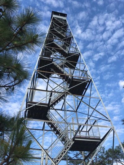
photo via facebook/Cherokee Ridge Alpine Trail Association
Smith Mountain is located in Dadeville, Alabama just off Young's Ferry Road. Here is the map to find Smith Mountain.
Since 1939, the Smith Mountain Fire Tower has stood like a sentinel over Lake Martin and the woodlands that cover its shores. It has been a landmark for boaters and a destination for hikers, who are treated to sweeping mountaintop views high above Lake Martin.
For four decades, the tower was vital in the fight against forest fires. After its decommissioning in 1980, the tower and site were left to the ravages of time. Thanks to donors like you, the tower was restored to better than original condition in Phase I of the Smith Mountain Park restoration project.
Trail Maps
See below in "Download Section" for Smith Trail Maps. Here is an overview description of the Smith Mountain Trails (also available as a download below).
Tower LoopTrail - From the Parking Lot it is a steep 0.4 mile climb to the base of the tower. A sign on the West side of the tower points to the return trail to the parking lot. Total length 1.0 mile. (It will seem further due to rugged terrain.)
Lakeshore Trail - Total length 2.4 miles. From near the top of the mountain, the Lakeshore Trail then makes a steep descent before winding gently along undeveloped shores of Lake Martin, returning to the parking lot through mixed hardwood/pine forest.
Island Hop/Boat Dock Trail - From Parking Lot it is approximately 1.4 mi. to the boat dock. When Lake Martin is lowered to winter pool levels, it is possible to walk another quarter mile crossing a series of islands inaccessible at full pool. The return trail from the boat dock to the parking lot is approximately 1.2 mile.

Little Smith Mountain Loop Trail - 2.6 miles
WARNING: This trail is spectacular for its views and rock formations, but is also the most difficult and potentially dangerous. At times the trail goes along sheer cliffs where a single misstep could have dire consequences. Do not attempt this trail unless you are sure-footed and in better than average physical condition. This is NOT a trail for small or unruly kids.
TRAIL MARKINGS
Rectangular paint blazes on trees at approximate adult eyeball height identify the correct trail paths. A double blaze either indicates a trail intersection or a sharp change in direction. DO NOT remark or change the trails.
The Hiking Project (another website) has an excellent description of this trail.
FOR MORE INFO VISIT CRATA.ORG